A Short Summary of Israel’s Geography

Scott Abramson, October 2023
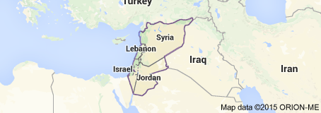
The state of Israel lies at the eastern edge of the Mediterranean Sea, at the intersection of three continents: Asia, Africa, and Europe. Together with its Lebanese, Syrian, and Jordanian neighbors, it forms the subregion of the Middle East variously known as the Levant, Greater Syria, and Bilad al-Sham. Since geography ordained the Land of Israel to be a land bridge between three continents, history, in turn, destined it to be both a crossroads of cultures and a borderland–and, thus, a battleground–for warring empires. For most of its history, the Land of Israel was ruled by such empires, often with the emperor’s seat or, at the very least, his writ in neighboring Egypt or nearby Mesopotamia.

But whereas Egypt has the Nile Delta and Mesopotamia the Tigris and Euphrates floodplain, the Land of Israel has no natural center, no geographical axis around which life in the country revolves. Israel lacks much else besides. It has no navigable rivers, little arable land, few freshwater resources and mineral deposits, and only a single, if mediocre, natural harbor. Nor is Israel the vast country its starring role on history’s stage would suggest for it. Indeed, if a country’s total area were proportionate to its historical glory, the state of Israel would cover a continent instead of a meager 8,000 square miles. To put Israel’s modest dimensions in American perspective, a cross-country road trip from Israel’s northernmost town, Metula, to its southernmost city, Eilat, can be accomplished in about nine hours. For further American reference, if Israel were a U.S. state, it would be the fourth smallest, its land (and population) slightly smaller than New Jersey’s.

California is another state that invites comparison with Israel. This isn’t because of its size, which exceeds Israel’s by a factor of twenty, but because Israel and America’s most populous state have several features in common: a well-watered north and an arid south; a Mediterranean climate of wet winters and dry summers; plate boundaries and fault lines of similar formation; a vulnerability to earthquakes; and a topography that supports a coastland, a parallel inland mountain range, an eastern desert, and a rift valley (i.e., a valley formed by tectonic movement, not by erosion). But as instructive California and New Jersey may be for reference, Israel’s geography is studied to better advantage on its own terms.
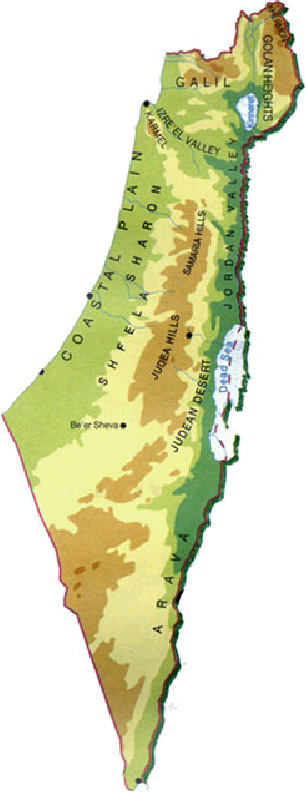
Israel is best understood as a country of three lengthwise sections, each defined by a different landform and each the Israeli part of a regional whole: coastland in the west, upland in the center, and lowland in the east. These three sections–namely, the Coastal Plain, the Central Highlands/Central Hill Country, and the Jordan Rift Valley–are themselves divisible into smaller geographical units. Since these three sections’ internal subdivisions have their own names, and since these subdivisions might appear in places to be unrelated, particularly where crossed by watercourses or valleys, the landscape can be deceptive. Accordingly, care should be taken by the student of Israeli geography to see, in the map of Israel, cohesion more than fragmentation. And this means looking at Israel’s three sections holistically.
The Coastal Plain
Bounded by the Mediterranean Sea on the west and extending from the Gaza Strip in the south to Lebanon in the north, Israel’s Coastal Plain is a thin ribbon of seashore that gradually broadens as its trends north-south. The Great Sea, the biblical name of the Mediterranean, is Israel’s outlet to the world, and as such, it was Israel’s lifeline throughout its neighbors’ decades-long siege.
Even the quickest glance at a map of Israel’s seashore is enough to register its most striking feature: its straight contour. Israel’s remarkably “regular coastline,” geographers’ term for a smooth and straight shoreline, arcs gently eastward with the gradual bend of a bow. Almost entirely unbroken by the dents of bays or the bulges of capes, the very “infrastructure” nature supplies for natural harbors, the otherwise straight line of the Israeli seaboard swerves only twice. The longer of the two swerves occurs where Mount Carmel juts into the Mediterranean and leaves only a sliver of shore between the sea and this sharply steepening mountain. Mount Carmel’s seaward push is what forms Haifa Bay, which, being both large enough to shelter vessels and deep enough to allow anchorage, is Israel’s only natural harbor. The second swerve from Israel’s straight coast occurs about 25 miles north of Haifa bay on the border with Lebanon. Here, at the northernmost point of the Coastal Plain, the white cliffs at Rosh Hanikra plunge into the sea.
Besides being remarkably straight, the Coastal Plain is remarkably narrow. Its effect on Israel’s human geography, however, is much greater because it is here, where the country is narrowest, that its population is also densest. Just nine miles wide at its narrowest point, the Coastal Plain is where almost sixty percent of Israel’s population is cramped and where Israel’s centers of culture, commerce, industry, finance are concentrated–to say nothing of its hi-tech industrial parks, diamond-polishing plants, and citrus farms.
The Central Highlands
The middle of the country’s three lengthwise sections, running parallel to the coast, is Israel’s mountainous spinal column, the Central Highlands. Here it becomes apparent that the Land of Milk and Honey is also a land of hills and valleys. The Central Hill Country might be imagined as a long chain of hills, its hills the links, the valleys the spaces in between. From north to south, the Central Hill Country alternates between these hill clusters and valleys:
- The fertile Galilee, bisected by the Beit Hakerem Valley into upper and lower halves
- The triangular Jezreel Valley, the largest gap in the Central Hill Country and, since it allows easy passage between the coast and the interior, the path of the main trade route in the Land of Israel throughout its history
- The diffuse hills of Samaria and the compact hills of Judea, the “Saddle of Benjamin,” a shallow valley, separating them
- The flat Negev Basin/Beersheba Depression and, to its south, the Negev Uplands, which proceed along a southwest-northeast orientation and terminate in the vicinity of Eilat
For millennia, the Central Hill Country had acted as a natural barrier, blocking westward and eastward passage and, thus, intercepting traffic between the sea and the interior. To this problem of access, the Jezreel Valley had always been the answer. It was only in the twentieth century that the mountain range finally ceased to be an obstacle, after locomotives, automobiles, and modern road transport enabled technology to triumph over terrain. Though no longer a barrier to movement, it remains a barrier to moisture from the Mediterranean. The mountains’ obstruction of easterly precipitation from the Mediterranean, an Israeli instance of a phenomenon known as the rain shadow effect, has left its mark on the Israeli landscape in a way that is visible to the naked eye: the hills are lush on the side facing the Mediterranean and parched on the other. The Central Hill Country’s topography is also what makes it a geostrategic asset, particularly in relation to the Coastal Plain. Possession of the lofty Central Highlands is the surest means to dominance over the narrow Coastal Plain.
The Jordan Rift Valley
Just as the Central Hill Country is merely the Israeli section of a much larger regional mountain range, so Israel’s third lengthwise section, the lowlands of the east, is part of a transnational geographical system: the almost 4,000-mile fissure in the earth’s surface known as the Great Rift Valley. This immense trench was formed by the fracturing of tectonic plates, and in Israel, as elsewhere along its journey across the earth, it shaped the surrounding topography and geology.
The Israeli segment of this depression in the earth’s crust is called the Jordan Rift Valley. Whereas the Central Hill Country alternates between hills and valleys, the Jordan Rift Valley alternates between valleys and lakes. Accordingly, the bottom of this great earthly trough is the bed of a lake where there’s water and the floor of a valley where there isn’t. For its part, the northernmost section of Israel’s Jordan Rift Valley, the Hula Valley, has been both a lake and a valley. In the 1950s, Lake Hula was reborn as the Hula Valley after the Israeli government drained what had long been a malarial marsh and reclaimed the land. The Hula Valley is also where the three sources of the Jordan River converge to form the glorified stream from which the rift valley takes its name. South of the Hula Valley is Israel’s only freshwater lake, Lake Kinneret, better known in the West by its misnomer, the Sea of Galilee. Lake Kinneret, which the Jordan River flows into in its north and out of in its south, divides the Jordan into upper and lower courses. South of Like Kinneret, where the Lower Jordan begins, the fertile Jordan Valley proper also begins. Through it, the Jordan River follows its downward course before emptying into the Dead Sea, a salt lake and, at some 1,400 feet below sea level, the lowest point on earth. South of the Dead Sea lies the arid Arava Valley, which marks the eastern border of Israel’s Negev Desert. The Negev, incidentally, is the opposite of the Coastal Plain in that it’s the tract of Israel that’s largest but where the population is sparsest. The Arava, which borders the Kingdom of Jordan on its other side, continues all the way down to Eilat.
October 2023