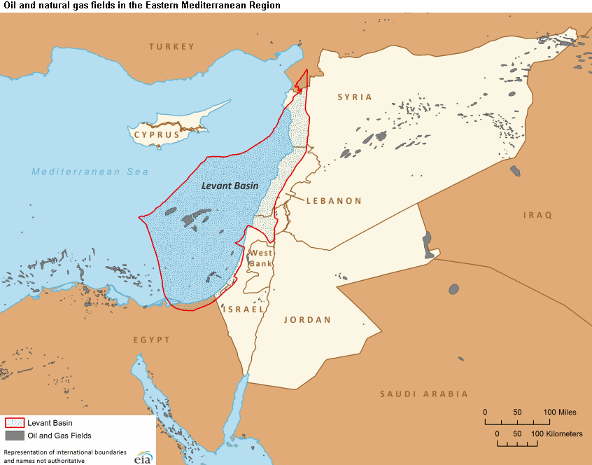
By Scott Abramson The State of Israel lies at the eastern edge of the Mediterranean Sea, at the intersection of three continents: Asia, Africa and Europe. Together with its Lebanese, Syrian and Jordanian neighbors, it...
![]()
By Scott Abramson The State of Israel lies at the eastern edge of the Mediterranean Sea, at the intersection of three continents: Asia, Africa and Europe. Together with its Lebanese, Syrian and Jordanian neighbors, it...

From the end of World War I until the June 1967 war, American Jewish attitudes toward Zionism moved from lukewarm embrace to full-throated support. The debate of American rabbis in the 1940s exemplified by this letter reflects attitudinal differences. The Holocaust, Israeli statehood and Israel’s stunning military success in June 1967 established Israel as a valued element in American Jewish identities.

Washington Institute Senior Fellow Michael Eisenstadt speaks about the regional effects of the 2023-2025 Hamas-Israel war and the ongoing U.S.-Israel-Iran war in March 2026.

President Trump’s speech a month into the war makes the case for Iran as a longtime U.S. enemy and argues that the war has largely succeeded and will soon be over.

Maya Rezak and Ken Stein, March 31, 2026 Videos and Multimedia Phillip Brown, “Middle East Oil,” Congressional Research Service, March 3, 2026. Yonit Levi, Nadim Koteich, Amer Al Sabaileh and Robert Satloff, “How Middle East…
Iran’s move to assert sovereignty over the Strait of Hormuz has short- and long-term implications for the Islamic regime and the world economy.

Golda Meir tells the U.N. General Assembly that Israel will comply with demands that it withdraw to the 1949 armistice lines with Egypt, but it expects U.N. support to keep the Straits of Tiran open.
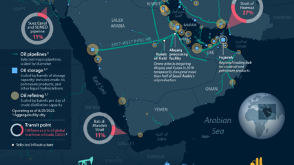
The Congressional Research Service shows where Middle Eastern oil is produced, refined, and shipped or piped.
The U.N. Security Council, on a 13-0 vote with two abstentions and with 135 co-sponsors from U.N. member states, enacts a resolution condemning Iran’s airstrikes on Arab states and its threat to the Strait of Hormuz.

For those looking for the best reads and watches on Iran and its relations with Israel, the United States and the Jewish people, CIE has compiled analyses, videos, documents and books.