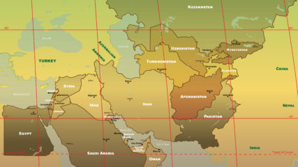
CENTCOM Area of Responsibility, 2021CIE+
The U.S. military’s Central Command is responsible for an area stretching from Egypt to Pakistan to Kazakhstan, including Israel since September 2021.
![]()
By Topic
Find content relevant to your specific interests or area of study.
By Type
Choose the format that best suits how you want to engage with the content.
By Language
Access content in the language that best supports your learning.
By Era
Explore content organized by historical period to focus your learning by timeframe.
The U.S. military’s Central Command is responsible for an area stretching from Egypt to Pakistan to Kazakhstan, including Israel since September 2021.
We use cookies to understand how visitors use our site and to show relevant content across the web. You can accept everything, reject non-essential cookies, or customize your choices. Privacy policy.