The maps presented below are only a few that could be used in learning and teaching about Israel and the Middle East.
CIE wishes to thank Aliza Cramer Elias and her team at the
Institute for Curriculum Services for allowing CIE to promote the use of the maps that they produced, found here in English and in Spanish.
Diplomacy and war reflect the changing contours of states and borders along the evolution of Israel and the modern Middle East. We wish to thank the Israeli Ministry of Foreign Affairs for allowing us to use some of their published maps. Others were made for CIE use.
Max Fisher has assembled
40 maps of the Middle East from ancient times to the present, each with a brief introduction. This is a first-rate collection with almost no noticeable bias and with a devotion to accuracy.
In addition, Michael Izady’s collection, the
Gulf2000 project, focuses on eight countries of the Persian/Arabian Gulf. Izady also lists other map collections, including
the Library of Congress, rich in historical items.
The University of Texas also has a
fine collection of Middle East maps, most of them drawn from the public-domain collection
created by the CIA.
Israel’s Ministry of Foreign Affairs provides
contemporary and historical maps of Israel and its neighborhood.
For Spanish-language maps, please click here.
For Hebrew-language maps, please click here.
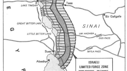
For Sadat, who had gone to war against Israel three months earlier, securing a military disengagement agreement was important. In addition, diplomatically engaging the US to secure the agreement meant entrenching Washington as a friend of Egypt. The US embraced the opportunity to quell tensions between Israel and Egypt, while squiring Cairo away from decades of Moscow’s embrace. Israel had its POWs returned and slowly tested Sadat’s broader intentions toward Jerusalem.
This map shows the State of Palestine as proposed by the Trump plan with features and selected locations from the Washington Institute Settlements and Solutions website.
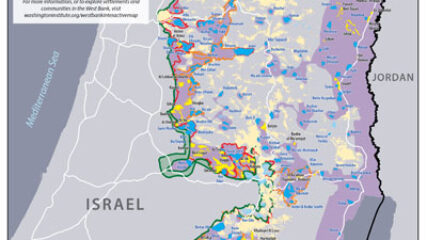
Israeli prime minister Binyamin Netanyahu has repeatedly declared that he will be putting forward his proposal for West Bank annexation as early as July 1. Yet uncertainties about his plans still abound, indicating that this timetable may not be met despite his assertions to the contrary.
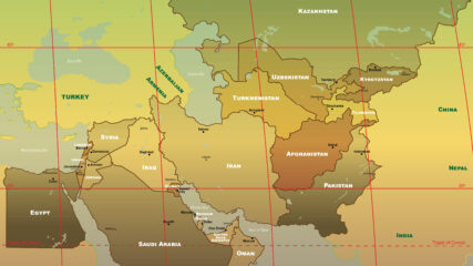
The U.S. military’s Central Command is responsible for an area stretching from Egypt to Pakistan to Kazakhstan, including Israel since September 2021.